ChROno
VoLcanO 3D
Interactive roundtrip to some hotspots on Planet Earth
This is an experimantal version of ChronoVolcano. Instead of the official Chronoscope 2.12, it utilizes Chronoscope 3D using Mapbox v2. (Chronocope 3D has not been launched yet.) The loveley new feature of Mapbox is a 3D model of the planet that can be explored here. Use Ctrl Drag or Click in the map and use Shift ▲ – Shift ▼ to tilt the pane.
Enjoy -Matthias chronohh mprove (Feb-2021)
We live on a hot liquid rock with a thin crust. The surface of Planet Earth is formed by tectonics and bubbling hot lava during millions of years. Here are a couple of hot spots visualized with the Chronoscope World.
Europe – The Atlantic – America – Pacific – Asia – Antarctica – Bonus
The Atlantic
Pico del Teyde on Tenerife
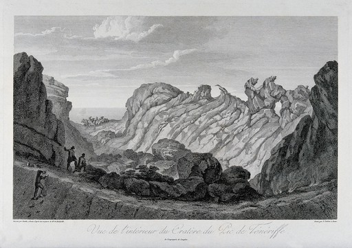
Crater view at Pico del Teide | Perpsective | Teide
Do you believe that this is the same spot?
- Altitudinal zonation of vegetation forms at Pico del Teide on Tenerife Timewarp Alexander von Humboldt 1817 /via ChronoAlex
La Palma at the Canary Islands
![]() Use the time pendulum – key Z – to loop the transparency.
Use the time pendulum – key Z – to loop the transparency.
Europe
Laacher See Lake Laach /last eruption about 12,900 years ago. hawk zoom
Dragney is a 700,000 year old volcano in Iceland. Well, the remains of the volcano.
The Fagradalsfjall has a live-cam! >> screenshots
Jules Verne’s science fiction novel Journey to the Center of the World starts at Snæfellsjökull on Iceland – while Stromboli provides the exit of the cave system.
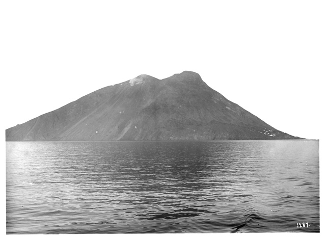
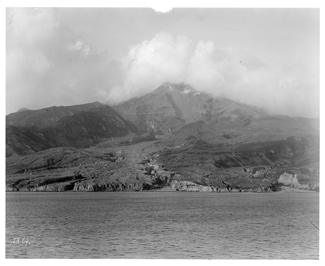
HAPAG Ahoi! Stromboli ca. 1909 (2 photos) Perspective
The dafault elevation scale is 1. It can be edited with X – just close the machine hangar with Esc
Did I mention that this is an experimental version?
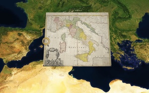
- Italy has several cold and hot volcanos; for instance the crater lakes:
- Lago di Bolsena Lago de Bracciano ol Vulcanus Sabatinus Lacus et Vulcanus Albanus
Mount Vesuvius destroyed Pompeii in 79 A.D. City plan
Alexander von Humboldt witnessed Versuv’s eruption in 1805. /via
More on Humboldt’s expeditions at ChronoAlex
The volcano is still active:
HAPAG Ahoi! Vesuvius ca. 1938 (7 photos)
Mount Etna hawk zoom Aetnae in Sicilia 1707
Vulcani e fenomeni vulcanici : Geologia d'Italia. Parte III / per Giuseppe Mercalli, 1883
americA
Mount Pelée on Martinique Perspective
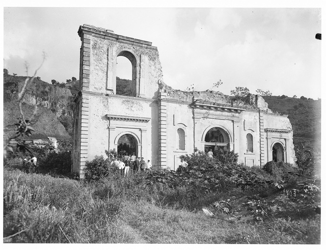
Ruins of Co-Cathedral of Our Lady of Assumption on Martinique after the eruption of 1902 Perspective
/via HAPAG Ahoi! #St. Pelée (8 photos) on #Martinique (34 photos) ca. 1909 #
Jorullo in Mexico satellite view of Jorullo hawk zoom Jorullo 1845
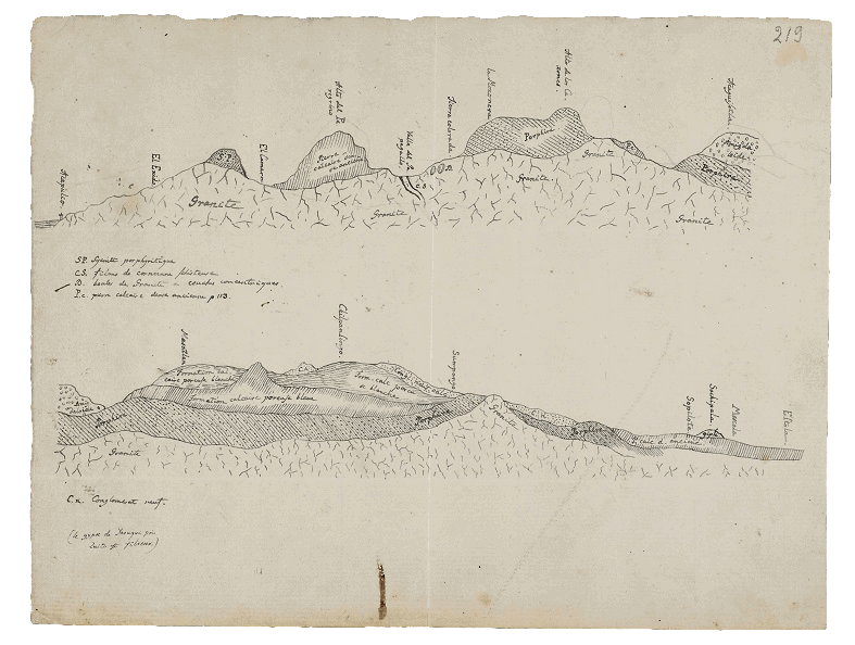
Geognostische Schnitt entlang des Weges zwischen Acapulco und Mexico-Stadt /via
Ecuador
Volcanos in Ecuador 1894 Volcanos in Ecuador 1897
Gipfel des Cotopaxi 5753m. Wenige electrische Explosionen mit Donner begleitet. –Humboldt
Gipfel des Chimborazo 6544m; die gemessene Basis durch Laplace’s barometrische Formel auf die Meeresfläche reduciert. – Viele leuchtende Meteore. –Humboldt

Humbold und Bonpland am Fuß des Chimborazo; von Friedrich Georg Weitsch (1810) /via
Quer_Profil durch das Hochland von Quito
Tiefenprofil von Santiago nach Buenos Aires
Pacific
On the ring of fire…
Sarychev Volcano Zoom in hawk zoom
Miyakejima – South of Japan
South-east Asia
Things I believe but cannot prove… Gilibanta Island
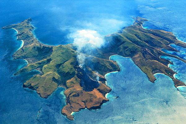
- Smithsonian Institute has no evidence for an eruption of Gilibanta for the recent 10,000 years. However, I believe that a volcano eruption has significantly reshaped the island after 1835. Some historical maps support this hypotheses; but are they accurate and reliable? A map from 1835 shows Glibanta with a convex shape:
- Gilibanta Island 1835
- Gilibanta – side map 1835 even with a »Pik«. Where is the peak today?
10 years later the shape is slim and concave; similar to the current outline:
Maybe the map from 1858 was not updated yet:
ChronoMedia :: Gili Banta Anchorage, Indonesia /a drone flight 9/2018
Next West: Gunong Api has two peaks
Plenty of smoking volcanos on Java
Antarctica
Mount Berlin The Berlin volcano was last active less then 10.000 years ago.
Bonus
Geologische Karte der Erde von 1820
R.E. Raspe: An Account Of Some German Volcanos, And Their Productions; 1776
Carl Cäsar von Leonhard: Vulkanen-Atlas zur Naturgeschichte der Erde; 1844
 Erwin Raisz (1893 – 1968) has drawn a set of geological illustrations about the upper layers of the Earth.
- From Ireland to England
- From Lubeck to Milan
- Click the map an proceed with key W
à propos
- Smithsonian Institute – Global Volcanism Program
- A meteor impact crater around Nördlingen maybe the only town in the world built using materials of extraterrestrial origin. Parts of a large meteorite that formed the crater it sits in was used for building the city walls, town houses, churches, … /via
More Projects by the Chrono Research Lab
Chronoscope World – interactive time-travel on More than 4,000 historical maps Lucky Map
> Chronoscope World Tour
> Cartographers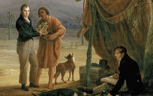
ChronoAlex – Alexander von Humboldts Erforschung der Neuen Welt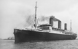
HAPAG Ahoi! – travel photography 1909-39
> Oswald Lübeck Kontaktabzug
> Franz Grasser Kontaktabzug