Im Rahmen des Kultur-Hackathons Coding Da Vinci Ost stellt das Leibniz-Instituts für Länderkunde e.V. seine historische Kartensammlung der Geographischen Zentralbibliothek unter cc0 Lizenz zur Verfügung.
Der Beitrag dieses Projekts ist die Aufbereitung der XML-Metadaten in eine interaktive HTML-Tabelle mittels einer XSL-Transformation. Die Lage der Karten kann im Chronoscope visualisert verwendet werden, so dass man orientiert ist, bevor man die Karte selbst im Browser aufruft. Suche und Filter machen den Datenmenge handhabbar.
Über die Sammlung
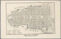
Die Sammlung besteht aus historischen Karten des 17. bis 19. Jahrhunderts. Darunter sind Weltkarten, Stadtpläne, Verkehrskarten, topographische Karten, Seekarten, Militärkarten oder auch physische Karten verschiedenster Regionen weltweit. Alle ca. 1400 Karten wurden digitalisiert und stehen als JPG- und hochauflösenden TIFF-Format bereit.
Des Weiteren beinhalten die Metadaten eine inhaltliche Erschließung in Form von festgelegten geographischen Schlagworten und einer nach einem geographischen Thesaurus erfolgten thematischen Zuordnung. Jede Karte wurde georeferenziert. Die entstandenen Koordinaten sind für eine Verortung im Raum verwendbar. /– Coding DaVinci Ost
ChronoAtlas (Home)
Log-Buch
MetaDaten-Sichtung
1127 records, 4MB. Per XSLTransformation kann die XML-Datei als Tabelle im Browser angezeigt werden.
- ChronoAtlas v1
- – sortiert nach ID
- ChronoAtlas v2.5
- – sortiert nach Erscheinungsdekaden plus Chronoscope als Orientierungshilfe
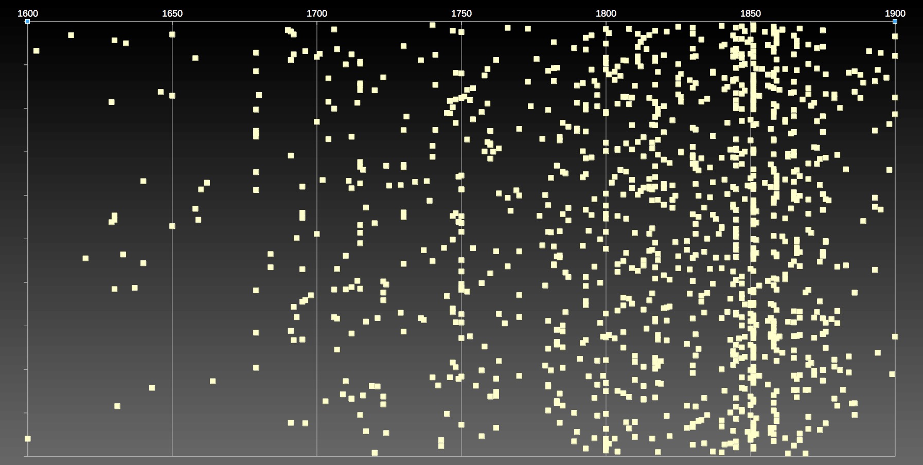
Karten von 1600-1900
IIIF
Alle Karten nach Jahr
Das Diagramm zeigt für alle 1127 Karten die Publikationsjahre an. Die Y-Achse hat keine besondere Bedeutung und dienst nur der Auffächerung der Datenpunkte.
- Für ChronoAtlas 2.5 werden alle Karten nach Jahrzehnt des Erscheinens sortiert. Sollte man ggf. lieber das abgebildete Jahr nehmen?
- HK1083
- Asia Antiqua
- HK1062 (1375)
- Faksimile einer Karte über Europa und Teile Afrikas aus dem Jahr 1375. In der chronologischen Sortierung von v2.4 sollte die am Anfang stehen => Update MetaData.
- HK0858
- 1400
- HK0499
- 1652 < 1852
- Would be nice to scan fot the first 4 digit string.
Issues, Problems, Bugs ⚓
MetaData Orientation
Bei einigen Karten (ca. 65) fehlt die Angabe der Nordpeilung, die im Code gepatcht wird. Die Liste hier ist insofern nicht mehr vollständig.
setWest
- HK0077
- HK0321
- HK0322: W oben
- HK0467: W oben
- HK0709
- HK0722
- HK1039: W oben
- HK1057: W oben
- HK1114: W oben
- HK1549: W oben & box needs to be twisted by 90° /Falklands
- HK1606: W oben, da die Karte um 90° gedreht eingescannt wurde.
- HK1632 – 01: W oben
setOst
setNord
- HK0725: N oben (die Seerose zeigt zum Magnetpol)
- HK0727: N oben (die Seerose zeigt zum Magnetpol)
- HK1520: N oben, nicht NNE
- HK1522: N oben, nicht NNE
SetSued
- HK0310: S oben / Seitenkarte Marion Islands (S oben) Lage
- HK0311: S oben
- HK0422a: Weltkarte, Coord W0 – E0 instead of W180-E180
- HK0458: S oben
- HK0948: S oben
- HK0968: S oben
- HK0972: S oben (statt "S. oben")
setNE
misc orientation:
orientation für Format B
- "HK0966","HK0970","HK1025","HK1638" /fixed 9/2019
Sonstiges
Ab v2.8 kann man die Lage patchen.
HK0078/II not visible- HK0078I ??
- HK0317 : 2 Einzelkarten in NArfrika
HK0109 Ostesee zu östlich /v2.8HK0162, HK1605: Box Osten zu weit im Osten /wenn man den Äquator anpeilt. /v2.8- HK0299: angegeben Jahr 1829 – aber das Eisenbahnnetzt ist bereits gebaut (oder überdeutlich eingezeichnet), vgl. Serie HK0284 – HK0306 Verwaltungskarte von Mitteleuropa
-
- HK0300 (projektierte Eisenbahnstrecken) vs. HK0299 (mit Eisenbahnstrecken)
- HK0301 Eisenbahn von Nürnberg nach Fürth; Ludwigseisenbahn
HK0332: Box muss nach S größer /v2.8HK0380: Box-Coordinaten zu weit /v2.8HK0471 zu groß > nur Sachsen, nicht auch Bayern /v2.8HK0493: Box-Coordinaten zu weit westlich /cf. Desden\Pirna /v2.8HK0545 Minden Box-Coordinaten zu eng für Brandys. MetaData für MindenHK0583: Box-Coordinaten müssen an die Westküste Griechenlands > Korfu /v.28- HK0422a/b: Polregionen: EW vs WE > patched
- HK0434: Dieses Hartenstein liegt nicht an der Wirschnitz?!
HK0445: Fast eine Kartehöhe nach N /v2.8HK0579: Verona liegt außerhalb NO /v.2.8HK0929: Box für Guadeloupe UND?! Seitenkarte St. Lucia /v2.8HK0947: Koordinatenfehler. Schwarzes Meer zeigt auf Straßburg /v2.8HK0960 liegt in Spanien ??HK0965: Rechteck 90° drehen wg. Stauchung, Box muss größer /v2.8HK0966, 1571, HK1615, HK1639-01: Coordinaten WSWSWS/ENENEN >> Format BHK0977: Box zu breit /v2.8HK0979: Linnay liegt links der Elbe /cf. Deutsche Fotothek: Karte der Gegend bei Linay in Böhmen, 1:35 000, Radierung, um 1750? /v2.8- HK1199: bessere Box-Coordinaten ??
HK1200 – 12: korrektes Atoll, aber zu klein im Maßstab. /v2.8- HK1200 – 14: doppeltes '-': E 168°55'00"--E 169°21'00"/N 10°05'00"--N 9°45'00" >> XMLPatch1200-14
HK1200 – 15: vielleicht hier /v2.8HK1200 – 11: Coordinaten vs. Behringstraße?? Hauptkarte Oben rechts /v2.8- HK1419: PermaLink defekt
HK1584: keine Box Coordinaten für Rio >> Fake + Patch /v2.8
Chronoscope 2.6 – Rotation<>90 – Issues TODO
HK0071 Hochformat /v2.8HK0071a " /v2.8
keine XML Metadata, aber thumbnail
- HK0589, HK0599, HK1058.9 (Kiel), HK1159
Sonstige XML Bugs
- HK0557 falsche Coordinaten und falscher PermaScan –> IfL HK0557
- Wo ist dann der Eintrag für den Scan: Höhenkarte Böhmen?
Einbindung des Chonoscope
- Lage/Ansicht Button sends XML bounding box and mapID to Chronoscope.
- bounding box is displayed as a dashed rect, mapID is a label on the top left corner
- mapID is used to get a preview from iiif. The image is displayed the same way as Chronoscope's Hamburg maps.
- Issue: 40 maps fail due to inconsistencies between mapID and iiifID
- Issue: some maps should be rotatated. Done for N/E/S/W. Rotation for 45°s and 22.5°s is TBD. How to rotatate a rect on a globe?
- Issue: persistent maps on day/night mapbox switch
Issue: map does not load on 1st pageload (to prevent a race condition)
- u=2 : keeps the opacity controls top left to control the Leibniz preview
- Issue: mobile CSS moves it to center bottom
- HK0075 gibt es doppelt. Damit klappt die radio/label Selektion nicht mehr, da der Name nicht mehr eindeutig ist /30.6.18
- HK0422a: special case antarctica: jumps on zoom
- Ideas
- load a JSON featureset of map images to offer fast feedback and high resolution
move LeibnizMaps out of script folder to chronoscopes folder- modify Victoria's sharing to share LeibnizMaps#HK1234 rather than ChronoLinks
- integreate LeibnizMap World √
XML/Chronoscope Bugs
- HK0665: W 5°16'00"-W 161°27'00"/N 80°35'00"-S 15°17'00" >> E 5°16'00"-E 161°27'00"/N 80°35'00"-S 15°17'00" => code fix
HK1083 – 1085: Asienbox EWNS instead of usual WESN?HK1163: keine Lage-Anzeige, da die Coordinaten "zu groß" sind.Firefox support /7-May-2018- HK0094 Lage in Bewegung und dann Lage für #HK0095 => Süd-America dreht nach Osten!?? Bug because turning is asynchrone.
ID mit Slash (zB "HK0081/III") -> Lage Button fail /18-May-2018- HK1062 shows 1375 and should be sorted as such
HK0223: peview in "wrong" rectHK0970, HK0966, HK1025 Coordinates Format B – twisted- HK0422a: Chronos Atlas vs. Chronoscope World sind um 180° verschoben | 1/2019
- HK0908: Chronos Atlas vs. Chronoscope World
Chronoscope Bugs
Anti-Meridian :: Issue 2415 /fixed
HK0907, HK0909, HK1067, HK1303: overlapping world coords #Halbkugel /fixed
- HK0422a Antarctica: BUG no map on zoom left
- HK0908: coords hack via code: meridian at 215
- HK0909: coords hack via code – south= -44
IIIF Issues
HK0006 : IIIF internal server error- HK0047a : IIIF internal server error
- HK0064, HK0027: IIIF map is turned left by 90° > falsche IIIF Vorschau, falsche Anzeige im Chronoscope. >> Patch at getIIIFURL
- HK0383 5k does not load/exist /chat an Leander >>
Meanwhile use 5109 to circumvent the bug || 4900 || 4800
- HK0949 not existing
HK1200-10: - HK1419 /srv/images/0006/HK1419.py.tif is neither a file nor part of an image sequence
- (HK1447) // IIIF crop bug
- HK1571 missing
Mehrteilige Karten
– done / Feb 2020 –
HK0536 4Teile
HK0561
9 Teile: HK0561 – HK0569. HK0562-69 sind nicht nicht mit ihren MetaDaten im XML erfasst.HK0579Scan und Koordinaten passen nicht, da es eigentlich 4 Karten sind.HK1119
Experimente mit allen Karten
Screenshots der Prototypen
Prototype 2.5.2a
A new mabox layer is created for each map and for each label. Obviously this is not the best idea in terms of performance.
Prototype 2.5.2.a2 /19-May-2018
All boxes in the same layer; all labels in one layer as well.
Pro:
- a boost of perfomance
- popup with link to ChronoAtlas
Cons:
- no color coding for age of map anymore
- no opacity relative to zoom for maps or labels
Prototype 2.5.2.a3 /21-May-2018
- 3 layers for 3 centuries
- Pros:
- more "visual flavor and historical depth"
- same performance
iiif thumbnails
challenge: What's the mapping between mapID and iifURL? At the moment we have 46 missing thumbnails – (which quite good for the first attempt).
[2-Jun-2018] error rate down to 0.5% (7 missing maps).
5k wird schwarz:
Referenzen
Kartographie & DataViz
MARC 21 XML Format und Transformation
Technology
Eingehende Links
Log
- Dec 2022: bugfixes in Chronoscope 2.13
- (Aug 2019: Chronoscope 2.8 with location patches)
- Oct 2018: rename LeibnizMaps to ChronoAtlas
- Sep 2018: integration of LeibnizMaps with Chronoscope Hamburg into Chronoscope World
- 10 Jul 2018: prev/next map buttons; keyboard support q/w, even if focus is in Chronoscope’s iFrame
- 9 Jul 2018: opacity controls even for preview maps
- 7 Jul 2018: crop maps by 2.5% margin; less top margin for tilted maps
- 3 Jul 2018: all world maps coords fixed and adjusted
- 30 Jun 2018: sort maps by release year and (second key) map ID. (Before was sorting by decade)
- 28 Jun 2018: last clicked [Ansicht] button stays selected :: change of A button into input radio + label
- 26 Jun 2018: size control for Chronsocope’s iFrame
- 23 Jun 2018: (Preview)Map loading on initial load
- 17 Jun 2018: 5k map resolution
- 16 Jun 2018: presentation in Leipzig
- 15 Jun 2018: Upload to github repository leibnizmaps: XML metadata, XSL transformation, CSS, Javascript
- 2 Jun 2018: IIIF previews down to 6 missing maps (0.5%).
- 31 May 2018 / Oct 2019
- 30 May 2018 LMv2.52: IIIF Map preview at 3k resolution inside Chronoscope’s frame; active opacity slider
- 27 May 2018 LMv2.51: hash-call or hash-update will move the Chronoscope immedeateley (after a sec) to the map’s location – leibnizmaps.js::doHashAnchor
- 17 May 2018 LMv2.5: search to filter the table for matching maps
- 7 May 2018
- v1: supported by Firefox and IE (by removing xsl:sort parameter
order="asscending")
- v2.4: supported by Firefox and IE (by using XSL 2.0)
- 3 May 2018 Hackdash project profile
- 30 Apr 2018 LMv2.4: sort by year published, relayout to 2 main table columns and 3 side columns, paper background
- 26 Apr 2018 LMv2.3: Chronoscope gets rotated for maps with North other than top.
- 19 Apr 2018 LMv2.2: anchor for each map. e.g. https://mprove.de/chrono?scope/atlas/xml_v2/iflzkw.xml#HK0260
- 17 Apr 2018 LMv2.1: dashed outline indicates map boundaries
- 11 Apr 2018: LMv2 – embedded Chronoscope to provide orientation based on rectification data.
- 9-10 Apr 2018: LMv1 – XSLT coding and fine-tuning to display XML Metadata
- 7 Apr 2018: content audit
Feedback – please leave a message
- I’d be happy to get your feedback via_
 Mastodon: @mprove@hci.social or chronohh@norden.social
 mprove@acm.org
- Other channels
Chrono Research Lab
à propos
By Matthias Müller-Prove. Created: April 2018, Modified: 9/18/23