Chrono Research Lab – Historische Perspektiven aus Hamburg
Some historical maps indicate that an vulcano eruption on Gilibanta Island has significantly reshaped the island after 1835.
Gilibanta vulcano index: 0604-051
today: Gilibanta ChronoLink – a concave shape
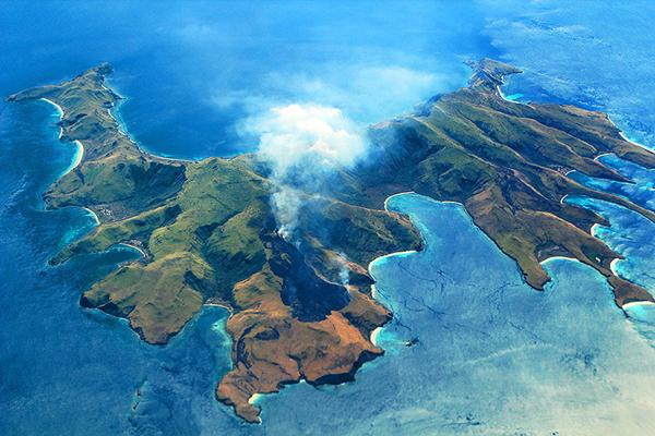
Gili Banta Anchorage, Indonesia /a drone flight 9/2018
The small island of Gilibanta was reported by a pilot to be destroyed by a volcanic eruption in 1957, but the report has not been confirmed by scientific sources and is considered doubtful (Hantke, 1962). Ratman and Yasin (1978) map the island as a Quaternary volcano with a caldera open to the north forming Ouingke Bay.
All maps since 1943 show esentially the same concave shape of the island.
Gili Banta – Diving Between Bali and Komodo | Part II /Adelaar Blog 12-Aug-2016:
Here you’ll be diving inside a partially submerged volcano. There aren’t many places in the world where you can dive a volcanic cinder cone. Don’t worry; it is unlikely you’ll see any fireworks from eruptions because Gili Banta has been dormant since her last submarine eruption in 1957. But the nutrient rich substrate continues to feed a plethora of marine life that thrives in this type of environment.
Komodo National Park Indonesia:
The islands in Komodo National Park are volcanic in origin. The area is at the juncture of two continental plates: Sahul and Sunda. The friction of these two plates has led to large volcanic eruptions and caused the up-thrusting of coral reefs. Although there are no active volcanoes in the park, tremors from Gili Banta (last eruption 1957) and Gunung Sangeang Api (last eruption 1996) are common.
1858: Gilibanta on HK0797 – a convex/round shape
1844: Gilibuanta on HK1086 – a slim/concave shape
1834. Presumably a stage before an vulcano eruption that destroyed half the island –– if the map is accurate
1898 – 1907 – convex/round shape
1908 – convex/round shape
87) Celebes, Java via William Hacke: A Pirate’s Cartographer <1682