ChronoAtlas is a web portal to access more than 1,200 historical maps dating from 17th to 19th century that have been provided under CC0 by the Leibniz Institut für Länderkunde. Discover new continents and oceans by browsing 62 GByte of scanned maps and 4 MByte of metadata.
The collection consists of historical maps of 17C and 18C. There are city maps, transportation maps, topographical maps, strategic military maps, sea maps, world maps and even astronomical maps of the stars and the moon. About 1.400 maps have been digitised with high quality and released under creative commons zero.
The maps are accompanied with metadata and tagged with a controlled geographic vocabulary. Each map has been rectified with geo coordinates that are used to place the map on it correct location on the globe.
Open ChronoAtlas or Chronoscope World
A Brief Usage Manual
- Maps and meta data need screen space. Hence mobile devices are only the second best idea to browse ChronoAtlas. If possible, use a desktop-browser with a large monitor.
- The Zoom buttons send the maps always to the same tab. Therefore it is possible to move this tab to a second monitor to display and study the 10K scans in full detail. Alt-Click the Zoom button to open a new tab.

left: Ansicht (View) / right: Zoom
- All meta data has not been translated into English. But you are clever enough to find your way.
- A note for Safari. By default the browser search function looks for beginnings of words, e.g. if you look for "Europa" you won’t find "Osteuropa".
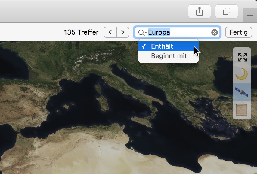
You might get better results if you switch on "Contains" as depicted above. Yes, the loupe is a menu!
- browse, discover and have fun!
A Walk-Through
Slides on SpeakerDeck | German edition
About
Social Media
Channels
Mastodon Tag Cloud
AngelsOnMaps
Chrono3D
ChronoAlex
ChronoFilmstrip
ChronoLink
ChronoLive
ChronoMedia+Glasperlenspiel
ChronoNews+ChronoFAQ+experimental
ChronoRecherche+HierSoAufDemSchirm
ChronoScroll
FilmeMitMundharmonika
HHFlut62
IIIFBooks+IIIFViewer
ISSTempus
Luftbildpläne
SilbermannReloaded
TicketToWatch
legacy xTwitter Tag Cloud
AngelsOnMaps aWalkInThePark Bahnhof Berlin CamæleoDaVinci Cholera chronoAlex chronoHHNews chronoLive chronoMedia chronoNews Chronoscope3D chronoTV codingdavinci crossGLAM Dransfeld drehortHamburg eCulture eCultureHH Egypt FritzSchumacher geoIxD GWLBHannover GroßerBrand Hamburg HAPAGAhoi! harbourcities HHFlut62 Hier so auf dem Schirm iiif iiifmaps iiifviewer ISSTempus Kraftwerk Hirschfelde LeipzigReloaded MapMonday mapsandcolours MonsterMonday mproveinsights New York Nicolai Nikolai openGLAM Oelsner portcities OTD railwayhistory Reeperbahn SilbermannOrgel SilbermannReloaded stabiHH Stonehenge TwitterSerendipity vpano WWII ZugangGestalten 30daymapchallenge
Former channels: Twitter: ChronoHH – browse on twuko | farcebook: Chronoscope Hamburg | tumblr: Chrono Hamburg
 Monetary Support
The historic and cultural time rides –as provided by the Chrono Research Lab– are a free service by Matthias Müller-Prove. You can explore more then 8,000 georeferenced old maps, browse through more than 5,000 info spots, and enjoy 42 ChronoScrolls and vintage photo sets.
On the other hand this means that there are some expenses on traveling across centuries. You can support future trips by your donation. Thank you!
 Support Me on Ko-fi
Tip via PayPal
Support Me on Ko-fi
Tip via PayPal
By Matthias Müller-Prove. Created: April 2018, Modified: 6/8/26