Historische Karten der Stabi Hamburg
cdvnord :: Hamburg- und Elb-Karten 1588 803 – 1939
Inhalt
- Daten
- Content Audit
- ContactSheet
- Chronoscope Hamburg
- google maps API & Tools
- Hamburg 1905
- Hamburg und Altona 1803
- Hamburg 1694
- Chronoscope Hamburg 1.x
- Chronoscope Hamburg 2.x
- Tools
- MapWarper
- MapTiler
- QGIS
- Einsichten
- Altona
- Sternschanze
- Zum ersten Bahnhof Hamburgs: Bergedorfer/Berliner Bahnhof
- Links
- Glossary
- Hackdash-Projekte
- Log
- Feedback
Daten
- Historische Hamburg- und Elb-Karten
1588803 – 1939 - Lizenz: CC BY 4.0 Staats- und Universitätsbibliothek Hamburg Carl von Ossietzky
Content Audit
- 241x tiff + xml / 6,38GB
- Reformatting to jpg2000, keep resolution
- 241x jp2 + xml / 3GB
- MetaData als OpenDocument Spreadsheet
- StabiHHKartenMetaData.ods
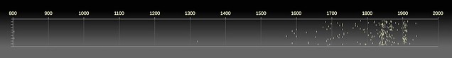
Die Datierungen als Plot:
StabiHH: mprove AntjeTheise Great!
ContactSheet
Alle Karten wurden in voller Auflösung nach Apple Aperture importiert. Hier ein Screenshot des Thumbnail-Views und danach ein PDF mit allen Karten – chronologisch sortiert – als Kontaktbogen.
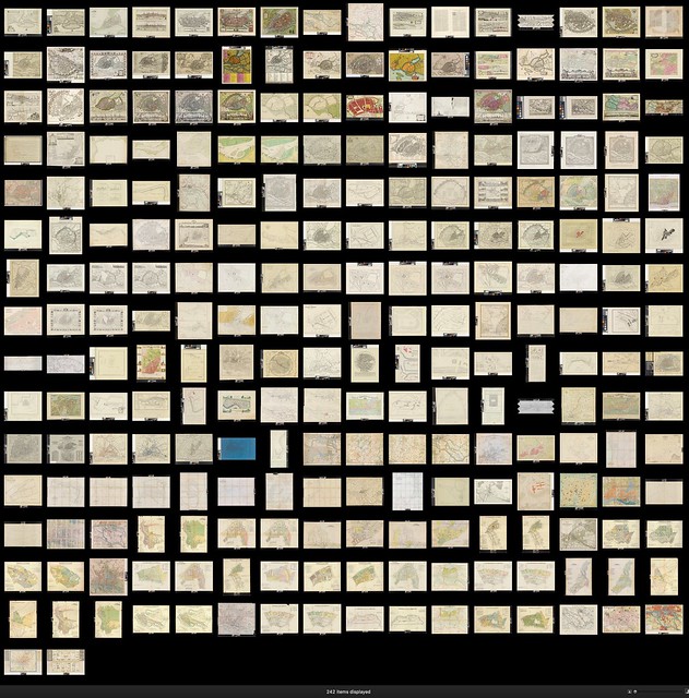
StabiHH_Karten_ContactSheet.pdf 280MB /v2 in chronologischer Sortierung
Chronoscope Hamburg v1.x
[PPN741316862] von 1929 bietet sich zeitlich an, um die Photos von Carl Dransfeld zu kartieren. Wie kann das technisch umgesetzt werden?
google maps API & Tools
Ein Versuch mit google maps_
- google maps API: Adding a Custom Overlay | Ground Overlays
- stackoverflow: Google Maps tool for accurately positioning image overlay?
- hongkiat: How to Style Google Maps
- snazzymaps – a WYSIWYG Google Maps Style Editor
Hamburg 1905 [PPN741220725]
- 5830x6000px, 6MB
Farben:
- Land: #d1b99f
- Park: #bba47d
- Wasser: #839487 /40%
Prototype
Chronoscope 1905 [link updated]
Markus Trapp: Sehr stark, was mprove da mit den Historischen Hamburg-Karten der Stabi (
s. Album: plus.google…) im Rahmen von cdvnord macht
gerhardkuehne: jetzt fehlen nur noch historische Fotos mit Location ;) Super Idee!
Features
- Vergleich zwischen Karte heute, damals und Satellit
- Harmonisches Farbschema der google Karte mit Betonung der Bahnstrecken.
- Transparenz einstellbar über Radio Control
- manuelle Korrektur der Karte, so dass sie auf die Topografie von heute passt
- manuelle Korrektur der Karte bzgl. des Offset der Farben rot und braun – select color, copy layer, offset & blending mode:Darken
Cons
- Ladezeit: ca. 15 Sekunden, bis die Karte von 1905 geladen ist. (6MB) – da die Scan-Aufösung allerding viel höher ist, als die Qualität der Karte, sollte man die Dateigröße ohne Verlust noch reduzieren können.
Hamburg und Altona 1803
- Altona [PPN612024857]
- Hamburg [PPN611207990]
Notizen
- Auf der Altonaer Karte ist Altona um 6° auf heutige GeoKoordinaten zu korrigieren.
- Auf der selben Karte ist St. Pauli im -4° zu drehen.
- Die HHer Karte muss um -1° gedreht werden. Außerdem ist die Scan-Auflösung im Vergleich zu Altona kleiner -> Scale up 148%
Prototyp
1803/v1: Chronoscope Altona & Hamburg 1803 [link updated]
BTW: Diese Karten wurden von User "TF8jYz6gkrO4" auch auf Map Wrapper eingepflegt.
Hamburg 1694
Und nochmal 100 Jahre früher: [PPN611982145]
skew & rotate & transform…
Prototyp
1694/v1: Chronoscope Hamburg 1694 [link updated]
Chronoscope Hamburg
Und jetzt alles zusammen. Die Landing-Page gibt Infos – außerdem versteckt sich hier als Nebeneffekt das Cachen der Karten mit 36MB.
 Chronoscope Hamburg
Done & ToDos
cf. Release Notes
Feature-Wunschliste
you are here -> requires https and certificate for the site√ v2.3- 1908 is the map w/ the lowest quality.
- Do we loose anything if it is scaled down?
transparency pendulum- -> space toggle visibility √
- [Error] Application Cache update failed
- because https://mprove.de/script/16/cdvnord/chronoscope/_media/cdvnord-maps.jpg was redirected.
- Links for Geo-Portal √
- Syntax:
http://www.geoportal-hamburg.de/Geoportal/geo-online/index.html?layerIDs=4608,452&visibility=true,true&transparency=0,0¢er=570340.8170159588,5931927.117919366&zoomlevel=7
- 94: Luftbild DOP 20
- 368: ALKIS farbig
- 453: Stadtplan
- –
- 2802: Vermessungskarte 2015
- 90: Vermessungskarte 2010
- 86: Vermessungskarte 2005
- 82: Vermessungskarte 1990-2000
- 78: Vermessungskarte 1980-90
- 74: Vermessungskarte 1970-80
- 70: Vermessungskarte 1960-70
- 66: Vermessungskarte 1950-60
- 62: Vermessungskarte 1940-50
- 58: OpenData Sonstiges Vermessungskarte 1930-40 /ziemlich komplett
- 54: OpenData Sonstiges Vermessungskarte 1925-30
- 4608: Kulturbehörde Vermessungskarte 1916-25 /ab zoom 4
- 4609: Kulturbehörde Vermessungskarte 1910-15
- 4610: Kulturbehörde Vermessungskarte 1900-10
- 4611: Kulturbehörde Vermessungskarte 1890-99
- 4612: Kulturbehörde Vermessungskarte 1880-89 /ab zoom 4
- mapboxzoom 15 = geozoom 6
mapboxzoom 16 = geozoom 7
MarineLives: Very nice – how about the ability for the user to add pop up data attached to the coordinates & to include a link – see dummy image?
MarineLives: (1) (Dreaming) of functionality u prob need user defined layers & ability to publish them to a Chrono common layer
(2) That way user can look at his/her specific annotations, and can work collaboartively on user oriented maps with public/academics
(3) But also have option to merge user specific map with other maps or with a Ur-Chrono-Map, with chrono map able to limit view of..
(4)..annotations to specific century (if wish) – like your slide/button choice on year of map in top LH corner of map

Chronoscope Hamburg v2.x
Zwischen Jan und März 2017 wurde google maps durch Mapbox GL ersetzt. Außerdem wurden alle Karten neu rektifiziert und eine Karte von 1590, 1657 und 1937 neu hinzugefügt. cf.
QGIS Rectification Step by Step
- choose a map
- crop the map to reduce the margin to a minimum
- prepare QGIS to georeference the map
- set the control points – focus on churches, bridges, street axes, …
- save control points for later updates
- open the georectified tiff – rotate no "normal" rectangular orientation – crop – add copyright – reduce to 4096 – save a jpg of reasonable filesize/quality (2MB)
- add map to Chronoscope – guess and measure corner points with QGIS and the Chrono Cursor of the Chronoscope. – update corner points – iterate until the map aligns with mapbox.
GeoJSON Info Layer
Chronoscope 2.5 (Mar 2018) can import and display geo point sets on the historical maps. It is used to display
- Dransfeld Photos between Wilhelmshaven and Berlin. Though, most are located in Hamburg
- Hamburg Residents of 1653 according to English High Court of Admiralty in London
How to convert the data to GeoJSON?
Dransfelds photosets have been mapped on a custom Google Map. The data can be exported to KML and then converted to GeoJSON. >> Chronoscope 2.5 w/ Dransfeld Photo Spots
pros
- reuse of custom google maps data
cons
- semantic icon info not (yet) mirgrated and unsed at Chronoscope v2.5
- all links redirect through goolge
Hamburg Residents info was encoded in JavaScript in Chronoscope v1.2. The data consists of streets (geo location and orientation) and a set of residents associated to the streets. A JS algorithm was used to spread several residents along a street.
Chronoscope v1.5a can export the data to (almost) GeoJSON format by dumping the code into the console window. Further adjustments of the locations were necesarry to match the info with the map of 1657 >> Chronoscope 2.5 w/ Hamburg Residents of 1657
TODOs
BUG chrome does not load the maps at allBUG fb cannot disply comma correctly – it is decoded by %2C insteadChrono Marker not always on top of all mapsself geolocation should set the chrono cursor – how to catch the event?
Rectification Glitches
1937
- Deutschlandhaus | Luftbild 1928 zeigt, wie die Dammtorstraße verbreitert wurde.
Ideas and Wishes
- hyperjumps von der jeweiligen Legende in die Karte
- 3D-terrain
- 3D-Hill shading √ Cronoscope 2.8
- 3D-Ocean ground -> mapbox 0.42 example >> map47 (no Gilibanta)
undocumentedfeature M - blend modes
Kai Krause: Memory Dots√ Chronoscope 2.9 /Sep 2020Kai Krause: Blending-Schaukeln zwischen Zeiten. "auch schön wäre ein Schaukel Effekt a bis b und zurück...5sec"share option as plugin/iframe√ Chronoscope 2.9 /Sep 2020 icon for show/hide
- generic tile server (QGIS Export quality is too low)
- ChronoPath :: flight via GeoJSON
- f Parameter to combine all binary flags
- crop static image ^GWLB :: top8 | cropperjs | Croppie
- 5+ponts image warp :: img-warp.js | distort-grid
- fun: liquid distortion | warp image | curtains.js
Libraries & APIs
- works for iOS and macOS – other OSs??
- no API parameter to rotate and tilt the map
Tools
Tools: Map Warper
Map Warper is a free to use, open source map warper / map georectifier, and image georeferencer tool.
Nice
- correction of distortion (rectification) based on customizable control point
- preview on inline OSM
- KML export displays maps in Google Earth
Issues
- JPEG2000 not supported.
- The TIFF-Export is blueish
- The export seems to be distorted and cannot be used as such on top of OSM or google maps.
Hannes says:This is a proper format for GIS like e.g. QGIS
Tim Waters – developer of QGIS – says:Generally, the GeoTiffs are in EPSG:4326 (lat/lon) like what you would see in Google Earth – but Google maps and OpenStreetMap are in spherical mercator (e.g.) EPSG:900913 (metres)
- The resolution is half the quality of the original StabiHH scans. Due to upload or due to Map Warper?? Maybe due to low-res uploads
What happend to the south part of Altona 1803?Fixed by a new point in the harbour.
WorldMap WARP – yet another instance of Map Warper. Differences to Map Warper:
- Base Layer can be changed to Google Street, Google Satellite, Google Hybrid
- export of original map file
MapTiler
MapTiler 7 is a commercial tool to tile maps, which can be used as tiled layers on top of google maps or OSM. The free version creates tiles with ''MapTiler' watermarks.
MapSlicer
MapSlicer is an open source project to slice the tiles for google maps and OSM. It shares the same root with MapTile.
MapSlicer requires wxPython, which is no longer supported directly on MacOS 10.11
QGIS
IFTTT
Would be nice: if fav on twitter then RT via buffer.
cf. HOW TO Schedule Your Retweets From Any Twitter Client
Einsichten
Altona
Chrono Research Lab: Altonas Stadtgeschichte aufgeschrieben 1780 /Transcript
Sternschanze
Chrono Research Lab: Wo lag die Sternschanze? Wie sah sie aus?
Zum ersten Bahnhof Hamburgs: Bergedorfer / Berliner Bahnhof
Chrono Research Lab: Eisenbahn in Hamburg | Rechereche
Referenzen / Links / Misc
- Was wäre wenn dieses Projekt nicht bei M$'s verstauben würde? :: Blaise Agüera y Arcas: How PhotoSynth can connect the world's images >>> Teile davon sind heute als IIIF open source.
- Locating London’s Past | Mapping Methodology of John Rocque's 1746 map of London
- Map Warper
- More maps projects
- M$ Research: ChronoZoom
Hamburg
- Hamburger Sammelsurium
- Hamburger Innenstadt: Der Ost-West-Konflikt /Zeit Online
- Tag des offenen Denkmals in Hamburg /Zeit Online
- Smart Square
- Sandtorhafen
WebApps
- Apple iOS WebApp meta tags – i.e. startup screens
- iPhone 6 Screen Size and Web Design Tips
- CSS Media Queries for iOS WebApps
- iPhone 6 Screens Demystified
- internal links
- enable iOS WebApp Cache
- Android/Chrome Manifest
Glossary
- GPS
- Global Positioning Systems (longitude is shifted about 100m East compared to Greenwich coordinates)
GPS essentially is WGS84 (World Geodetic System 1984) - cf. WGS84 and the Greenwich Meridian
- CRS
- Coordinate Reference System
- georectification
- OSM
- Open Street Map
Hackdash-Projekte
Log
Sep 2018
- Chronoscope Hamburg/World 2.6 contains all map data of ChronoAtlas and displays maps world wide.
19.3.18
- Chronoscope 2.5 :: migration from mapbox 0.32 to 0.39, migration of ChronoCursor from Chronoscope 1, scale control, slider control for transparency, GeoJSON info layer for residents 1650 and Dransfeld photography
1.4.17
7.3.17
18.2.17
- Chronoscope 1.3: Karte von 1694 rektifiziert mit QGIS – 99 Kontrollpunkte
27.10.16
- open source & cc by-na 4.0 for content & the interaction model
13.10.16
12.10.16
9.10.16
8.10.16
- Prototype: Chronoscope Altona & Hamburg 1803 /v1 [link updated]
- Prototype: Chronoscope Hamburg 1694 [link updated]
7.10.16
- Chronoscope 1905 /v3 [link updated] mit korrigiertem geographischem Mapping
6.10.16
- Chronoscope 1905 /v2 – Smartphone-ready
- Chronoscope/v1
27.9.16
- Contact Sheet mit chronologischer Sortierung aller Karten
- MataData als OpenDocument Spreadsheet: StabiHHKartenMetaData.ods
26.9.16
- Datum des Dargestellten kodiert im Aperture Version Name. So lassen sich alle Karten zeitllich sortieren.
Feedback – please leave a message
- I’d be happy to get your feedback via_
 Mastodon: @mprove@hci.social or chronohh@norden.social
 mprove@acm.org
- Other channels
à propos
- Ahoi User Experience Design, mediale 16
- StabiHH-Dransfeld :: Architekturfotos aus Hamburg der 1920er Jahre